Phase II Archaeological Excavations at the Colonial Williamsburg Visitor Center Williamsburg, Virginia
Block 33-2
Colonial Williamsburg Foundation Library Research Report Series - 1665
John D. Rockefeller, Jr. Library
Colonial Williamsburg Foundation
Williamsburg, Virginia
2002
Phase II Archaeological Excavations at the Colonial Williamsburg Visitor Center
Williamsburg, Virginia
The Colonial Williamsburg Foundation
Department of Archaeological Research
P.O. Box 1776
Williamsburg, VA 23187-1776
Principal Investigator
Marley R. Brown III
July 1999
Management Summary
From March 17 through April 22, 1999, the Colonial Williamsburg Foundation's Department of Archaeological Research (D.A.R.) conducted a Phase II assessment of portions of the Colonial Williamsburg Visitor Center property. The assessment was conducted in order to establish the significance and boundaries of four sites identified during the 1998 Phase I survey of the property, also conducted by the D.A.R.
Testing consisted of the systematic placement of fifty-six 75-cm-square test units and sixteen round shovel tests within the areas previously identified as potential sites. Units were dug stratigraphically to the level of undisturbed subsoil. All soil excavated was screened using a ¼-inch steel mesh screen. All artifacts recovered were saved for laboratory analysis. Only the portions of the sites not under parking lots were tested.
The Phase II assessments revealed that the major portions of three of the four sites identified by the Phase I survey appear to extend under the Visitor Center parking lots. Although it is difficult to determine without excavating the cores of the sites, it is likely that little survives of these sites. The core of the fourth site is located off of Visitor Center property on land owned by the National Park Service.
Native Americans first occupied the terrace that now contains the Visitor Center complex. Artifacts that date to the Early Woodland phase (3200-2500 BP [before present]) were found on at least two of the tested sites. The historic occupation of this terrace dates to the late eighteenth century to mid-nineteenth century and probably represents the remains of tenant farms leased from absentee landlords.
Site 1 is located on a slope north of the Colonial Williamsburg YMCA Child Care Center parking lot. The Phase I suggested it was an early nineteenth-century farmstead. During the course of the 1999 assessment uncovered a light scatter of artifacts but no concentrations of artifacts were found and no features were identified. This site appears to be a peripheral portion of a site that extends underneath the Child Care parking lot. Indeed, as the site is located on a slope it is also possible that the artifacts recovered have merely been washed off the terrace and down the slope over time. The area has also been plowed.
Artifacts recovered during the Phase II assessment include a gunflint, white salt-glazed stoneware, wine bottle glass, pearlware, nails, and delftware, among others, and confirm the Phase I conclusion that this was part of a domestic site.
Site 2 is located to the southeast of the Group Arrivals Building. Located on the southern edge of the terrace that contains the Visitor Center complex, this site contains both prehistoric and historic components. The presence of prehistoric and historic finds located within the same layer confirms the area has been plowed. Neither significant concentrations of artifacts nor features were unearthed during the excavations, leading again to the conclusion that this area was actually on the periphery of a larger site now located under parking lot.
iiThe prehistoric component of the site was much more substantial than the historic component. Prehistoric artifacts included several pieces of quartzite debitage, a projectile point, worked flakes, fire-cracked rock, and net-pressed ceramic. Historic artifacts included cut nails, wine bottle glass, and brick. No intact cultural layers or features were identified.
Site 3 is also located southeast of the Group Arrivals Building. It is located partially on a terrace, and partially on a north-south slope. Artifacts associated with a prehistoric occupation were more substantial than those associated with the historic occupation. Like Site 2, this area has been plowed, as prehistoric projectile points were located in the same layer as nineteenth-century ceramics.
Site 3 is similar to Site 2, although its historic finds were more substantial than those at the latter. Prehistoric finds included coil-built net-pressed ceramic, a projectile point, and worked quartzite flakes. Historic finds included wine bottle glass, creamware, whiteware, pearlware, mocha yellow ware, window glass, and nails. The number historic and prehistoric artifacts were substantial enough to indicate that this area was relatively close to the main component of the site. Again, however, no features were located, indicating that the core of the site was most likely to the northeast of the excavated area, beneath the Group Arrivals Building and parking lot.
Site 4 is located south of the Visitor Center "Blue" parking lot perimeter road and north of the Colonial Parkway. It sits on a high flat terrace, artificially created when the ground was cut away in order to build the parking lot and the Parkway. A large portion (over 50%) of the terrace was left untested due to the fact that it lies on National Park Service property.
Both historic and prehistoric artifacts were unearthed. The prehistoric occupation is represented by two pieces of quartzite debitage. Much more was found in the way of evidence of a historic occupation including whiteware, creamware, pearlware, nails, wine bottle and window glass, and brick, among others. Again, no features were uncovered. It is difficult, however, to draw any conclusions with regard to Site 4, as so much of the area on which it is located could not be excavated as it lies off the Visitor Center tract. A Phase II assessment of National Park Service land will have to be completed in order to fully understand the site's significance and extent.
Recommendations
As it is likely that significant portions, and in some cases almost the entirety, of these sites are located beneath the present Visitor Center complex and parking lots, it is recommended that archaeological monitoring take place during all phases of the proposed renovations. It is quite possible that the construction of the parking lot has obliterated the remains of these sites. If, however, features relating to these or other sites are uncovered during the process of renovation, it is recommended that Phase III excavations be conducted prior to completion of said renovations.
Acknowledgments
The successful completion of this project was due to the hard work of a number of people. The entire project was conducted under the general supervision of Dr. Marley R. Brown III, Director of the Department of Archaeological Research at the Colonial Williamsburg Foundation. Staff Archaeologist David Muraca oversaw the project and provided support throughout. Project Archaeologist Lisa Fischer supervised the first phase of the project, including most of the excavations at Sites 1 and 2. A dedicated and hardworking field crew consisted of Lucie Vinciguerra, Katherine Schupp, and Mark Kostro. Donna Sawyers cataloged and interpreted the artifacts. Heather Harvey and Lucie Vinciguerra prepared the graphics. Greg Brown edited and formatted the report. Andrew Edwards provided his customary moral support and helped work up the prehistoric portion of the report.
Table of Contents
| Page | |
| Management Summary | i |
| Acknowledgments | iii |
| List of Figures | v |
| Chapter 1. Background | 1 |
| Introduction | 1 |
| Environmental Setting | 2 |
| Prehistoric Overview | 3 |
| The Paleoindian Period | 3 |
| The Archaic Period | 4 |
| Early Archaic | 4 |
| Middle Archaic | 5 |
| Late Archaic | 6 |
| The Woodland Period | 7 |
| Early Woodland | 7 |
| Middle Woodland | 7 |
| Late Woodland | 8 |
| Historical Overview | 10 |
| Previous Archaeology | 11 |
| Chapter 2. Research Design and Methods | 12 |
| Research Goals | 12 |
| Field Methods | 12 |
| Laboratory Methods | 12 |
| Chapter 3. Research Results | 14 |
| Site 1 | 14 |
| Site 2 | 15 |
| Site 3 | 16 |
| Site 4 | 17 |
| Chapter 4. Summary and Management Recommendations | 19 |
| Summary | 19 |
| Recommendations | 19 |
| References Cited | 20 |
| Appendix A. Artifact Inventory | 22 |
| Page | |
| 1. General location of project area | 1 |
| 2. Close-up of project area | 2 |
| 3. Plan view of Site 1 | 14 |
| 4. Profile map of test unit 881/1115 | 14 |
| 5. Plan view of Site 2 | 15 |
| 6. Profile map of test unit1089/1061 | 15 |
| 7. Plan view of Site 3 | 16 |
| 8. Profile map of unit 850/1040 | 16 |
| 9. Plan view of Site 4 | 17 |
| 10. Profile map of test unit 507/540 | 17 |
Chapter 1.
Background
Introduction
 Figure 1. General location of project area.
From March 17 through April 22, 1999, the Colonial Williamsburg Foundation's Department of Archaeological Research (D.A.R.) conducted a Phase II assessment of portions of the Visitor Center Property (Figures 1 and 2). The project was undertaken in order to establish the integrity, boundaries, and significance of four potential sites identified during the 1998 Phase I survey of the property (Gilmore 1998). The Phase I survey was conducted in order to identify potential sites that may be negatively impacted by the proposed renovation of the Colonial Williamsburg Visitor Center. Gilmore (1998) classified these sites as having both historic and prehistoric components and theorized that the historic components were most likely related to nineteenth-century farmsteads.
The Phase II assessment focused on areas which had turned up positive shovel tests during the Phase I. Phase II excavations substantiated the Phase I conclusions, indicating that there were indeed four sites within the project area. Unfortunately, in each case excavations appear to have uncovered only the peripheral portions of the sites. The topography consists of a large terrace with gently sloping sides. It is likely that the core portions of
2
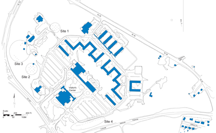 Figure 2. Close-up of project area.
these sites are located in areas that serve as parking lots for the Visitor Center complex, the Group Arrivals facilities, and the YMCA Child Development Center. The majority of information regarding these sites has no doubt been buried beneath these buildings and their parking facilities, leaving only a fringe of artifact scatter at the outermost edges of the plateau and on the slopes leading down from the terrace.
Figure 2. Close-up of project area.
these sites are located in areas that serve as parking lots for the Visitor Center complex, the Group Arrivals facilities, and the YMCA Child Development Center. The majority of information regarding these sites has no doubt been buried beneath these buildings and their parking facilities, leaving only a fringe of artifact scatter at the outermost edges of the plateau and on the slopes leading down from the terrace.
Environmental Setting
Each of the four areas investigated during this survey warrants specific environmental description. Site 1, located northeast of the Child Care Center parking lot, slopes gently toward the northeast into a ravine and then up onto a narrow terrace of land running north to south. Vegetation included mature deciduous and coniferous forest. The area has been plowed and was a friable sandy loam.
Both Sites 2 and 3 are located south of the Group Arrivals Building facilities and are bounded on the northwest, west and southwest with a ravine and stream. A picnic area and associated shelter were located near the southern end of the tested area. The soil in this area had been plowed. Vegetation consisted of a mature deciduous forest toward the north while a mature pine forest grew toward the southern end of the area. A ten-centimeter-thick pine needle mat covered a friable sandy loam soil matrix under the pine forest.
3Site 4 is wooded with a mature growth of pine, live oak, and American holly along with moderate secondary vegetation. Soils consist of friable sandy clay loam and sandy clay subsoil. The area lay upon a terrace bounded by the Blue Parking Lot perimeter road to the north and a rugged slope that descends toward the Colonial Parkway toward the south.
Prehistoric Overview
Native American culture, prior to European contact, can be divided into three main periods: the Paleoindian period, the Archaic period, and the Woodland period. The Paleoindian stage of cultural development lasted from 12,000-10,000 BP (years before present). The Archaic stage lasted from 10,000-3200 BP and is subdivided into three separate stages of cultural development. These are: Early Archaic (10,000-8500 BP), Middle Archaic (8500-5000 BP), and Late Archaic (5000-3200 BP). The Woodland period lasted from 3200-400 BP and is also subdivided into three cultural stages. These are: Early Woodland (3200-2500 BP), Middle Woodland (2500-1100 BP), and Late Woodland (1100-400 BP). Each of these stages of Native American prehistory are marked by notable socio-cultural and material changes.
THE PALEOINDIAN PERIOD (12,000-10,000 BP)
Debate has long raged within the academic community over the date and method of human settlement of North America. Current research places the earliest definitive inhabitation of the United States at around 12,000-10,000 BP. The most likely point of entry for these first inhabitants of the North American continent is from Asia via the Bering Land Bridge (Turner 1989; Brown et al. 1986).
Paleoindians arrived in Virginia around 10,000 BP. During this time, the Pleistocene era, the last of the ice ages, was coming to an end. The climate shifted dramatically, with warmer temperatures and decreased precipitation. These shifts exposed large sections of the continental shelf upon which the Tidewater sits and which were previously and are currently under water. Even the forests adjusted, becoming dominated by oak and pine. Large game animals like the mammoth and mastodon were replaced by smaller modern animals such as the deer, turkey, and turtle (Metz et al. 1998). This shifting climate greatly influenced the life ways of the Paleoindians, turning them away from big game hunting and toward the gathering of plant food and hunting of small game (Blanton and Kandle 1997).
Paleoindians manipulated their settlement patterns and tool kits to fit their environment. They lived in band level societies operating across a large, relatively fixed area (Blanton and Kandle 1997). They utilized small base camps and outlying hunting camps, both on a temporary basis. Generally these sites were chosen based on the availability of both rock for tool making (essentially jasper and quartz) and animals for hunting. Very few of these sites have been discovered in Virginia, the notable exceptions being the Thunderbird and Flint Run Paleoindian Complex sites in northwestern Virginia and the Williamson site in Dinwiddie County (Turner 1989). No substantial sites have been uncovered in the 4 Williamsburg area, though individual points relating to the Paleoindian period have been located in disturbed contexts, namely plowzone (Brown et al. 1986).
The most common component of the Paleoindian tool kit uncovered by archaeologists is the projectile point and flakes related to its manufacture. The earliest projectile tool produced by Paleoindians and unearthed in Virginia is the Clovis Point. It predates Dalton-Hardaway Points and is the most heavily represented on Paleoindian sites in Virginia. It is a relatively thin point, lanceolate and fluted, with a concave base and lateral and sometimes basal thinning (Johnson 1989). The Dalton Point (one of which was uncovered during archaeological excavations at the Bruton Heights School Complex in Williamsburg) is a broad, thin blade with finely serrated edges, a slight excurvature, and a sharp point. The appearance of Dalton points indicates a shift in technology from a Clovis-dominated tool kit to one that contained tools designed for specific purposes (Metz et al. 1998).
Paleoindian sites are rare around Williamsburg and on the Peninsula in general. No intact stratigraphic sites exist in the Tidewater and most of the points recovered are from heavily plowed areas. This has to do partially with the fact that the jasper and quartz, so attractive to Paleoindians for tool making, are not available in significant quantities in the area. Additionally, many of the areas in the Tidewater that would have been habitable during the late Pleistocene are now covered with water. Therefore, any analysis of Paleoindian culture on the Virginia Peninsula comes from the examination of the dozen or so points recovered in isolation on unstratified sites (Blanton and Kandle 1997, Brown et al. 1986; Reinhart 1989).
THE ARCHAIC PERIOD (10,000-3200 BP)
The Archaic period is marked by a shift from the late ice age environment of the Pleistocene to the more modern environment of the Holocene. Populations increased during this period, leaving behind a richer and more complex archaeological record than their forebears.
Early Archaic (10,000-8500 BP)
As with the Paleoindian period, there is an academic debate surrounding the Early Archaic period. Many scholars argue that because it shares much in common culturally with the Paleoindian period, the Early Archaic should be subsumed within it (Blanton and Kandle 1997; Brown et al. 1986). Indeed, the climate and environment remained much the same, with similar boreal forests populated with the same game animals and food resources (Custer 1990). For the purposes of this paper, however, a more traditional approach will be taken in which the years from 10,000-8500 BP are contained within the Archaic period.
The Early Archaic also had much in common culturally with the Paleoindian period. Inhabitants of Virginia continued to organize themselves in band level societies. Settlement patterns remained much the same, with base and hunting camps over a large but well defined area. During this period some larger base camps were established along the Chickahominy and James Rivers (Brown et al. 1986).
5There were changes in the basic tool kit during the Early Archaic period. Projectile points became corner notched and serrated. The earliest of these corner notched points is the Palmer point which was in use circa 10,000 BP. This was followed by the Kirk Notched, which becomes a part of the tool kit around 9300 BP. The Kirk Stemmed point is the latest of these new points coming into existence circa 9000 BP (Custer 1990). Less common notched points from the period include Kessell, Charleston, and Amos. The primary use for these points continued to be the procurement of animal food stuffs, though tools such as stone adzes and grinding slabs become a part of the tool kit during the Early Archaic as well (Blanton and Kandle 1997).
As with the Paleo-Indian period, very few Early Archaic sites exists on the Peninsula which have been discovered and/or investigated archaeologically (Custer 1990). There are no known intact stratigraphic sites on the James/York Peninsula. Lack of data is a key factor in the continuing debate about where exactly the Early Archaic belongs in the cultural and temporal record.
Middle Archaic (8500-5000 BP)
The most significant changes during the Middle Archaic were environmental. Warmer, moister temperatures and greater seasonal variation led to changes in Native American settlement patterns. They continued to live in band level societies, occupying temporary camps in search of food, however, the habitats in which they settled became more varied (Blanton and Kandle 1997; Custer 1990). For the first time, inhabitants of the Holocene moved into the upland interiors of Virginia. There are two possible explanations for this move to the uplands. The first is related to shrinking group territories due to increased population (Blanton and Kandle 1997). The second is related to the spread of deciduous trees into new areas due climatic changes. This increase in deciduous trees led to an increase in the number of productive habitats which could be taken advantage of by native inhabitants. It is quite likely that these two causes worked in tandem to draw Native Virginians into the upland areas (Custer 1990).
Tool kits also changed during the Middle Archaic period. There was a move during this period away from the use of highly localized quality jasper and quartz and toward the use of local stone for tool making. It was also during this period that bifurcate forms came into use, followed by Stanly, Morrow Mountain, Guilford, and Halifax points. These stone points were of much lower quality than the tools of the Paleoindian and Early Archaic periods (Custer 1990). The Middle Archaic also saw an increase in the use of more informal tools geared toward the high mobility of a band level society (Blanton and Kandle 1997).
The Middle Archaic period has, like the Early Archaic, left little evidence behind to guide us toward an understanding of its culture. This is especially true of the Tidewater area. Coastal flooding and the rising sea level have most likely destroyed many of the sites on the James/York Peninsula. There is speculation that the lack of sites may also be related to poor survey coverage of the area (Custer 1990). The site most relevant to the Peninsula is the Slade site in southeastern Virginia, which included bifurcate points and a human burial with associate burial goods including an end and side scraper and a chipped stone 6 adz (Geier 1990). Enough is known about the Middle Archaic to classify it as the "beginning of a continuum of cultural adaptation which concludes with the establishment of a network of highly adapted localized Hunter Gatherer communities during the Late Archaic" (Geier 1990: 84).
Late Archaic (5000-3200 BP)
Here we find those highly adapted and localized hunter-gatherers of whom Geier spoke. They, unlike their predecessors, had the advantage of living in a fully developed Holocene environment with stabilized estuaries and sea levels. According to Dent (1995) this lead to a scheduled and seasonal procurement of food, or what is known as a collectors strategy (cited in Blanton and Kandle 1997).
Inhabitants of the Late Archaic period established semi-permanent base camps at stream heads on upper terraces and on the gently sloping south sides of lower terraces (Blanton and Kandle 1997; Mouer 1991). These camps were not permanent settlements though some were used repeatedly over the course of many seasons. Inhabitants also continued to frequent outlying camps for the purposes of hunting animals and gathering plant foods. During this time, Native Americans became highly adapted to the deciduous forest environment of the Holocene, settling in areas where the soils are best suited to the growth of large stands of nut bearing hardwoods. Nuts were a key element of the Late Archaic diet, along with turkey and deer. Because of this, most sites in Virginia are clustered around the base of the Blue Ridge Mountains (Mouer 1991).
Though not to the extent as previous periods, there continues to be a dearth of information left behind by residents of the James/York Peninsula during the Late Archaic period. Obviously Native Americans were living in the area, as evidenced by the Deep Bottom site on the James River and the Keck, Reynolds Alvis, Nase, and Posnick sites on the Chickahominy River (all in Henrico County). However, the most archetypal site from the period is the Halifax Complex in the Virginia/North Carolina Piedmont. The site is named for the diagnostic Halifax points found there. The Halifax point, along with the Lamoka, Lackawaxen, Brewerton, and others, is highly representative of the period (Mouer 1991). Other tools which find there way into the tool kit included ground stone axes, carved stone bowls, and stone drills.
Mouer (1991) would argue that a large part of the Late Archaic should actually be classified as the Transitional period (roughly 4500-3200 BP), a term first coined by Witthoft in 1953. The argument for this classification is that during this Transitional period inhabitants of the Late Archaic became increasingly riverine, meaning they settled along and relied heavily upon rivers. The Transitional period is also earmarked by the appearance of soapstone bowls and "broad spear" points (Mouer 1991). Although the Transitional period is classified within the Late Archaic, it is important to note that this riverine adaptation and change in tool technology occurred around 4500 BP. It is at this time that large shell middens first appear, marking Native Americans new reliance on rivers and their inhabitants.
THE WOODLAND PERIOD (3200-400 BP)
The Woodland Period is the best understood of the three major periods of Virginia prehistory. Significant advances, both technological and cultural, occurred during this period. During the Woodland phase, population greatly increased, ceramic vessels were first produced, certain plants were domesticated, and inhabitants moved from band to tribal and finally to chiefdom level social organization. It is, like the Archaic, divided into three sub-periods.
Early Woodland (3200-2500 BP)
The Early Woodland saw the expansion and intensification of the native subsistence base (Hodges 1991). Though in some ways it continued to be like the Late Archaic, especially in the reliance on rivers and particularly fish and oysters, several significant changes did occur during the Early Woodland.
Residence of the Early Woodland made the move toward more sedentary living, while continuing to utilize outlying hunting camps (Blanton and Kandle 1997; Hodges 1991; Mouer 1991). It was during this period that groups began to utilized more circumscribed territories. Mouer (1991) argues that they also instated buffer zones, which were not settled by any particular group, but which were used by a variety of groups and separated one "territory" from another. It is also likely that during this time more extensive trade networks were developed over larger areas with active trade occurring between groups within these newly developed buffer zones (Blanton and Kandle 1997; Mouer 1991).
Essential to the characterization of the Early Woodland is the introduction of ceramic bowls. This technology provides a solid material departure from the Late Archaic period. The nomenclature and technical distinctions between different ware types is quite complex and beyond the scope of this paper, but suffice it to say that coil built, cord marked, sand and/or soapstone tempered ceramics are common finds on Early Woodlands archaeological sites (Mouer 1991).
Though there are few sites across the Peninsula, their numbers increase from the Chickahominy River west. For the most part, these "sites" are likely outlying hunting camps, as evidenced by the shell middens located at the York River State Park (Blanton and Kandle 1997). Mouer (1991) posits that perhaps part of the coastal plain was contained within one of the previously mentioned buffer zones, explaining why small encampments, rather than more sedentary village sites, have been located. It is quite possible that the area was used extensively for trade and food procurement, but not settled, even semi-permanently, by any one group.
Middle Woodland (2500-1100 BP)
It is during the Middle Woodland period that native populations of Virginia began organizing themselves into tribal rather than band level societies. This is by far the most significant of the transitions that occurred during a period fraught with change. Many of the cultural traits we recognize as "Native American" came into existence during this middle phase of the Woodland period.
8Stewart (1992) defines two basic phases of cultural and material development for the Virginia coastal area during the Middle Woodland period. Middle Woodland I is represented by Popes Creek and related ceramics and lasts from 2500 to 1800 BP. The second phase, Middle Woodland II, is represented by Mockley and Mockley-like ceramics and lasts from 1800 to 1100 BP. Although there is an abundance of ceramics during this period, including Prince George and Varna, Popes Creek and Mockley are the most telling. Generally they are shell tempered and course and are found throughout the Coastal Plain during the Middle Woodland.
During this period relatively extensive trade networks in ceramics and stone for tool production developed across Virginia. The coastal plain of Virginia is a part of a pan-Mid-Atlantic culture in the sense that its ceramic patterns are similar to sites from Maryland to the James River. This argues for a degree of cultural homogeneity, perhaps caused by the use of ceramic ware distribution in order to foster inter-group cooperation. (Blanton and Kandle 1997; McLearen 1992; Stewart 1992). This indicates a much more highly developed trade and communication network than was seen in the Archaic or Early Woodland periods.
Subsistence patterns remained much the same as the Early Woodland with a continued heavy reliance on local plants, small game, and fish and oysters from local rivers. However, for the first time, inhabitants of the Middle Woodland began to selectively nurture, or possibly even domesticate, local plants. (Blanton and Kandle 1997; Stewart 1992). This domestication, however rudimentary, was absolutely essential to the development of the Late Woodlands more intensive agriculture.
Settlement patterns also varied only slightly from those of the Early Woodland. People continued to live in semi-sedentary base camps with satellite collector sites (Blanton and Kandle 1997). The larger base camps were located in settings where a variety of plant and animal resources were readily available. Often this meant near a salt/fresh water interface. The smaller satellite camps were then placed along streams and used for collecting during various parts of the year. Populations of each group or "tribe" were supervised by an achieved-status "Big Man" who managed their communal subsistence projects (Stewart 1992).
Middle Woodland sites are much more abundant than Early Woodland sites. This is true of much of the Peninsula. The 1992 excavations at the Locust Grove Tract at Carter's Grove Plantation revealed both a Middle Woodland hearth and a separate procurement site (Moodey 1992). The best known sites on the coastal plain are the Maycocks Point, Hatch, and Irwin sites in Prince George County, and the Diascund Creek and Aignon #3 sites in New Kent County (McLearen 1992). Although much more is known about the Middle Woodlands than previous periods, it is still relatively untouched archaeologically.
Late Woodland (1100-400 BP)
The late Woodland is the best understood of all Virginia's pre-contact periods. It was during this period that Native Virginian's made the move toward sedentary village life and established first a tribal level of social organization and later in the period a chiefdom.
9According to Turner (1990), the Late Woodland is best characterized as a period of rapid change. The period saw "an increase in the importance of agriculture and local lifeways accompanied by increased population, larger, sedentary villages, and increasingly complex means of social integration" (Turner 1990: 97). Throughout much of the period, native populations lived in tribal organizations, with groups of 1000 or less residing most of the year in sedentary villages. Ties were established along kinship lines and status was achieved. It wasn't until near the end of the period, around 1600, that chiefdoms began to emerge (Blanton and Kandle 1997). The Algonquian Powhatan represent the culmination of the changes which occurred on the coastal plain during the Late Woodland, becoming the dominant chiefdom on the Virginia coastal plain (Turner 1990).
Economically, the inhabitants of the Late Woodland established a sophisticated collector system based on hunter gatherer technology augmented by agriculture and a highly refined understanding of local resources and their availability. Native Americans planted beans, pumpkins, squash, and maize using a form of agriculture known as "swidden" in which fields are cleared from the forest and used on a rotating basis (Blanton and Kandle 1997; Turner 1990). With the rise of chiefdoms, a more sophisticated society, and increased population, cultivated plants (along with deer skins, mussel shells, etc.) were not only important for their nutritional value, but also as statements of wealth. By the end of the Woodland period, smoked oysters were being used as trade/tribute (Barfield and Barber 1992).
Shell tempered wares dominated the Late Woodland period. There was quite a bit of ceramic variability throughout the Tidewater, though shell tempered Chickahominy ware was known generally throughout the area. Chickahominy was accompanied by another shell tempered ware, Townsend which was often fabric impressed or incised. However, by the end of the Late Woodland a plain type Townsend ware is found to the exclusion of other wares in the Tidewater, and specifically in the core of what was the Powhatan Chiefdom, namely the confluence of the Pamunkey and Mattaponi, and along the York River and portions of the lower Rappahannock (Turner 1990).
By the end of the Late Woodland the Tidewater area was dominated by the Powhatan chiefdom. The James and Upper York drainages became the domain of the Powhatan and included six petty chiefdoms. When necessary, the Powhatan used force to subsume what amounted to thirty-two native groups into their chiefdom, though it is thought that their hold over these groups was probably tenuous (Blanton and Kandle 1997). A system of tribute was instated, with the chief of the Powhatan living and receiving tribute in a sedentary village such as Werowocommoco on the York River (Barfield and Barber 1992).
Virginia coastal plain during the Late Woodland, according to Turner (1990), is better represented archaeologically than most of eastern North America. Site 44JC398, located on the Chickahominy River, represents a Powhatan village occupied prior to and just after European contact (Blanton and Kandle 1997). White Oak Point (44WM119) contains a well preserved shell midden and faunal dumping ground. The Addingon site (44VB9) represents a spring and summer fishery (Barfield and Barber 1992). Although there remains a relative lack of stratified sites which have been excavated and interpreted, the remains of stratigraphically disturbed camp sites have been located throughout James City 10 and York Counties. However, the Late Woodland and Protohistoric eras continue to take a back seat to Historic sites in the Tidewater area. (Brown et al. 1986).
All in all, the Late Woodland represents a fascinating period of Virginia pre-history. Supplemented by oral histories and observations of the first Europeans in Virginia, the archaeological record of the Late Woodland provides a fascinating look into a sophisticated civilization with complex social, economic, and political organization.
Historical Overview
The office of the governor of Virginia during the seventeenth and eighteenth-centuries embodied several attractive perquisites, not the least of which was the landed estate that came with the office. Three thousand acres near Jamestown were set aside in 1618 by the Virginia Company to provide income and a residence for Governor Yeardley and his successors. The governor lived on part of the land while the remainder was rented to provide valuable revenue to the governor throughout the seventeenth and eighteenth-centuries until the Revolution.
The governor's residence was moved to Williamsburg shortly after the new capital was constructed on the site of Middle Plantation in 1699. The Governor's Palace was built on a seventy-five acre tract partly in the city and partly in York County. The combined income from the Governor's Land and this parcel was more than adequate to support the residence and office of the Governor. In 1768, eighty-seven additional acres were purchased from the estate of Lieutenant Governor Francis Fauquier. This parcel consisted of two parcels including fifty-two acres, acquired in January 1760 from John and Elizabeth Ferguson, and a thirty-five acre parcel acquired in May 1760 from Mathew Moody. Two hundred additional acres were added during the tenures of Lords Botetourt and Dunmore. By 1775, over three hundred sixty-four acres comprised the Palace Lands adjacent to Williamsburg. The College of William & Mary acquired both the Governor's Lands and the Palace Lands through an act of the General Assembly in 1784. By 1786, Edmund Randolph had acquired the Palace Lands through an unrecorded transaction and by 1790 the land had reverted back to the College. The Rev. Dr. Samuel Smith McCroskey purchased the three-hundred sixty-four acre Palace Lands tract from the College in June 1790. Rev. McCroskey served as Rector of Hungais Parish in Northhampton County from 1774 until his death in 1803 (Virginia Magazine of History and Biography 9: 298).
The history of the Palace Lands during the nineteenth-century revolves around a succession of doctors, lawyers, and professors who resided in and outside Williamsburg. Using the Palace Lands Papers (1815-1866), a chain of title can be traced for this century. Robert F. N. Smith administrated the estate of Rev. Dr. McCroskey in 1815. Robert Saunders acquired the tract including all buildings at auction from the McCroskey estate for $11.50 an acre in 1816. The parcel was evidently passed on to his son Robert and his wife Lucy (daughter of Governor John Page) as they sold it to John and Amanda Gregory in 1838 for $3,000. As the son Robert was only eleven years old when his family acquired the land in 1816, the land was passed it to him when he reached a more mature age. In 1833, Robert Saunders (the son) was made a professor of mathematics at William and 11 Mary and in 1847 he was made president pro tem. He also served as the head of the Eastern State Lunatic Asylum prior to the Civil War (Tyler 1915:217). John M. Gregory graduated from William & Mary with a law degree in 1830. He served James City County in the House of Delegates until 1841 when he was elected to the Council of State. He became lieutenant-governor in 1842 and acting governor in 1843. Gregory was appointed a district attorney and then Circuit Court judge in succeeding years. He retired from public service in 1880 and died in Williamsburg in 1888. The Gregorys sold the Palace Lands for $3,300 to Dr. Samuel S. Griffin in July 1841. Apparently, Dr. Griffin sold the Palace Lands parcel to Dr. Van F. Garrett sometime prior to 1866 as a deed of life interest for a house in the tract was acquired by Lovey T. Jackson from Dr. Garrett in that year. Dr. Garrett was one of the Directors of the Eastern State Asylum and served as President of pro tempore of its board during this time (Calendar of State Papers 1893:483). In 1904, the Southern Land Company received the Palace Lands (now called Garrett Farm) from Dr. Garrett for $5,000 (Palace Lands Papers 1815-1866, 1904).
The project area is included in the original seventy-five acre tract acquired by the Governor's Council in 1700. Only one site located thus far dates to the eighteenth-century occupation of the property. Three other historical sites relate to the early nineteenth-century ownership by the Saunders family. Documentary evidence indicates that these lands were used as pasturage, orchards, and farms. During the eighteenth-century the land was known as "the park" (Gibbs 1980:5). The 1781 Desandrouins map depicts ravines, woodlands, cleared areas and some roads and outbuildings. It is highly likely that the property owners during the eighteenth century leased the land to others or had slaves farm parts of the land to support the governor's household. The property owners during the nineteenth century probably leased the property to farmers.
Previous Archaeology
Site 44WB90 was identified during the June 1996 Phase I survey of eighteen acres behind the Colonial Williamsburg Visitor Center. Phase II and III investigations identified the site as a slave quarter associated with the Palace Lands. An irregularly-shaped feature with burnt clay and brick in its fill and an English-bond brick hearth and associated robber's trench were uncovered during investigations. Phase III investigations at site 44WB90 have taken place during the summers of 1998 and 1999.
A Phase I survey was conducted in the fall of 1998, covering areas of the Visitor Center Complex not tested during the 1996 Phase I. During the course of the 1998 Phase I survey five potential sites, most with both historic and prehistoric components, were located. This Phase II is an attempt to better understand four of these sites which may potentially be impacted by renovations to the Visitor Center complex.
Chapter 2.
Research Design and Methods
Research Goals
The research design for this Phase II investigation was based on findings from the 1998 Phase I survey. As discussed in Chapter 1, the Phase II assessment attempted to define spatial and temporal boundaries of four previously identified sites. Additionally, the Phase II intended to evaluate the integrity and significance of the four sites.
Field Methods
Testing consisted of systematically placing 75x75-cm-square test units at ten-meter intervals within the areas previously designated as potential sites. In areas of higher artifact concentrations, intervals were collapsed to every five meters. Units were placed on the grid established during the Phase I survey. All units were assigned coordinates for their northwest corner with respect to the original datum point, 1000N/1000E.
A total of fifty-six 75x75-cm units and sixteen shovel test were placed across the project area. All units were excavated using shovels and hand trowels. Soil removed from the units was sifted through a ¼-inch hard wire mesh screen. Units were excavated following the natural stratigraphy of the soil. The majority of units had been heavily plowed; thereby mixing the stratigraphy into what is referred to as plowzone. All units were excavated to the level of subsoil, which was then examined for cultural intrusions.
Each layer was assigned an individual context number. Artifacts from each context were bagged accordingly. An Archaeological Context Record was entered into an on-site palmtop computer for each context. Information regarding the artifacts, soil layers, and cultural remains was included in each record. At the end of each day, information from the palmtop was downloaded into the DAR's database, Re:Discovery. Typical stratigraphic profiles were recorded for each excavation area. The location of each test unit was located on a site map. Information from context records and plan and profile maps were used to identify and analyze layers, features, and artifact concentrations.
Laboratory Methods
All artifacts recovered during the excavation were sent to the DAR's archaeology lab for processing and analysis. Artifacts were washed, identified, and inventoried, by context. Each context was assigned a terminus post quem (TPQ) date when possible. The TPQ date establishes the earliest date at which an archaeological layer, feature, or artifact assemblage could have been deposited. This date is always based on the artifact with the most recent initial date of manufacture. Artifacts were inventoried by ware type with all important functional and morphological characteristics noted. All of the documentation and artifacts recovered during the excavation are stored at the D.A.R. Laboratory.
13Extensive plowing of the excavation area, along with soil erosion, had mixed modern with eighteenth- and nineteenth-century layers. TPQs were thus often much later than the occupation period on which the excavation focused. This was taken into consideration when interpreting both laboratory and field data.
Chapter 3.
Research Results
Site 1 (Figure 3)
Site 1 had a relatively uniform and a straight forward stratigraphic profile (Figure 4). A thin layer of topsoil was followed by a layer of plowzone roughly 20 cm deep. Artifacts recovered included a gunflint, white salt-glazed stoneware, wine bottle glass, pearlware, nails, and delftware. Artifacts were scattered in low concentrations across the assessment area. No cultural features were uncovered.
Site 1 is located on a south-north slope. It is probable that the artifacts recovered were transported from the Visitor Center terrace along with eroding soil and then plowed. This leads to the conclusion that the site itself is actually located on the terrace under the employee parking lot and that the artifacts recovered were originally located in this area.
Site 1 appears to have been a domestic site. However, without features and with so few artifacts present, a more exact determination of the type of domestic site (e.g., slave
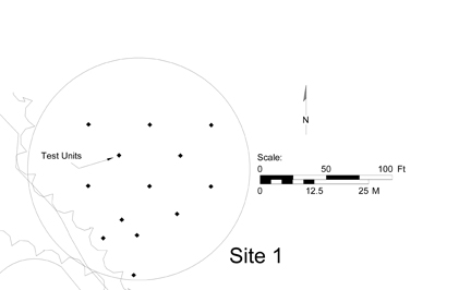 Figure 3. Plan view of Site 1.
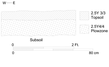 Figure 4. Profile map of test unit 881/1115
15
quarter, tenant farm, or middling farmstead) is impossible. Brick concentrations were low and may have been from a foundation, hearth, or brick home.
Figure 4. Profile map of test unit 881/1115
15
quarter, tenant farm, or middling farmstead) is impossible. Brick concentrations were low and may have been from a foundation, hearth, or brick home.
Site 2 (Figure 5)
Site 2 contained both historic and prehistoric components. Artifacts from both occupation periods had been plowed together. The stratigraphic profile was similar to that at Site 1 and was relatively uniform across the site (Figure 6). Roughly 10 cm of topsoil sealed 20 cm of plowzone which came down on sterile subsoil. The only features uncovered were scars made by plows, again confirming that the area was extensively plowed.
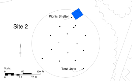 Figure 5. Plan view of Site 2.
 Figure 6. Profile map of test unit 1089/1061.
Historic artifacts included cut nails, wine bottle glass, and brick. Concentrations were light across the tested area, with the majority of test units yielding no finds. Any conclusions drawn about the nature of the site would be shaky, as so little evidence was uncovered. However, the presence of historic artifacts does argue for human occupation of the area during the eighteenth and/or nineteenth centuries. The assessed area lies on the southernmost edge of the terrace and is most likely on the periphery of a larger site, whose features and denser artifact concentrations lie below the employee parking lot.
Prehistoric artifacts recovered include quartzite debitage, a projectile point, worked flakes, fire-cracked rock, and net-pressed ceramic. Finds indicate that the site was occupied 16 by Native Americans during the Early Woodland period (3200-2500 BP), when sand tempered ceramic first came into use on the Virginia Peninsula. During this period native Virginians lived in small semi-permanent camps while utilizing outlying camps for hunting and gathering forays. Site one represents one of these temporary procurement sites. Fire cracked rock indicates more than a passing presence, while light artifact scatter points to the site's ephemeral nature leading to its classification as a procurement site rather than a more permanent base camp.
Site 3 (Figure 7)
Like Site 2, Site 3 contained both historic and prehistoric components and had been heavily plowed, providing for a straightforward stratigraphic profile (Figure 8). Historic artifacts point to a late eighteenth/ early nineteenth-century occupation period and include wine bottle glass, creamware, whiteware, pearlware, mochaware, window glass, and nails. Located on a north-south slope at the southwest edge of the Visitor Center terrace, this site, like Site 1, was most likely subject to erosion, causing artifacts to move from the terrace itself down the slope. Since artifact concentrations were much heavier in this area than at site one, site three was likely closer to the core of its larger site. The core of Site 3
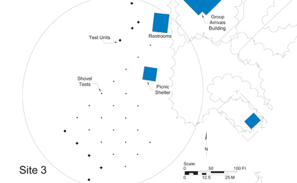 Figure 7. Plan view of Site 3.
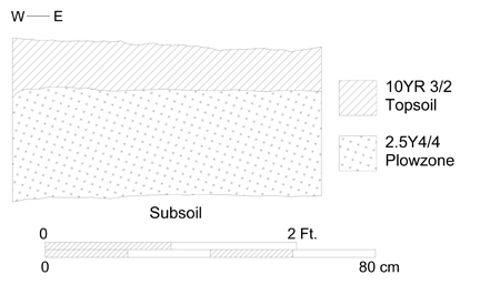 Figure 8. Profile map of test unit 850/1040.
17
is most likely located below the Group Arrivals Building complex and the picnic area restrooms.
Figure 8. Profile map of test unit 850/1040.
17
is most likely located below the Group Arrivals Building complex and the picnic area restrooms.
Historic artifacts recovered during excavations again point to a domestic site. However, without architectural remains (foundations, postholes, etc.) the status of the occupant/occupants is difficult to determine. By the nineteenth century, ceramic type is less of a status indicator, as similar assemblages may be found on both planter-class estates and slave quarter sites. Quantity is much more helpful in determining status. However, with the core of the site unavailable for examination and the assessed area lying on a slope, actual artifact quantity is unclear as is the nature of the site itself.
Prehistoric finds included coil-built, net-pressed, sand-tempered ceramic, a projectile point, and worked quartzite flakes. Like Site 2, this represents an Early Woodland procurement camp, most likely seasonal in nature.
Site 4 (Figure 9)
Site 4 revealed evidence of both an historic and prehistoric occupation. As previously stated, much of Site 4 is on National Park Service property and could not be tested. This severely limits the conclusions that can be drawn as to the nature of the site. The stratigraphic profile consisted of thin topsoil followed by 20-30 cm of plowzone, although in several cases all natural stratigraphy had been stripped away and replaced with clay fill during the road construction process (Figure 10). Historic artifacts included whiteware,
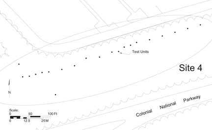 Figure 9. Plan view of Site 4.
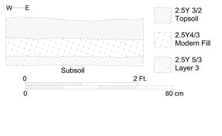 Figure 10. Profile map of test unit 507/540.
18
creamware, pearlware, nails, wine bottle and window glass, and brick. No cultural features were uncovered. Like the previously discussed sites, Site 4 was also most likely a domestic site, with the same limitations preventing further analysis of the site. Only two pieces of quartzite debitage relating to the prehistoric era were uncovered and do not provide enough data to accurately place the site either temporally or culturally.
Figure 10. Profile map of test unit 507/540.
18
creamware, pearlware, nails, wine bottle and window glass, and brick. No cultural features were uncovered. Like the previously discussed sites, Site 4 was also most likely a domestic site, with the same limitations preventing further analysis of the site. Only two pieces of quartzite debitage relating to the prehistoric era were uncovered and do not provide enough data to accurately place the site either temporally or culturally.
Chapter 4.
Summary and Management Recommendations
Summary
This Phase II assessment was conducted in order to establish the significance, boundaries, and integrity of four sites identified during a Phase I survey of the area conducted in September/October 1998. Although the construction of the Visitor Center Complex had obviously destroyed much of the terrace stratigraphy, it was hoped that enough information remained on the periphery to adequately identify and analyze the four sites.
With this goal in mind, fifty-six 75-cm-square test units and sixteen round shovel tests were placed within the areas previously identified as potential sites. Although these units turned up both historic and prehistoric artifacts in quantities sufficient to indicate long-term human occupation, not enough data was left to draw any substantial conclusions. No cultural features were located to indicate the types of structures that may have comprised the four sites. These features, along with the artifact concentrations that would be grouped around them, are destroyed by the Visitor Center and buried beneath its surrounding roads and parking lots. Whether anything survived the construction process has yet to be determined.
Recommendations
As significant portions of these sites are located beneath the present Visitor Center complex, it is recommended that archaeological monitoring take place during all phases of the proposed renovations. It is likely that the construction of the complex has obliterated the remains of the sites. If, however, features relating to these or other sites are uncovered during the renovation process, it is recommended that large-scale excavations be conducted prior to the completion of said renovations.
References Cited
- 1992
- Archaeological and Ethnographic Evidence of Subsistence in Virginia During the Late Woodland Period. In Middle and Late Woodland Research In Virginia: A Synthesis, edited by Theodore R. Reinhart and Mary Ellen N. Hodges, pp.225-248. The Dietz Press, Richmond.
- 1997
- Comprehensive Archaeological Survey of Jamestown Island. Jamestown Archaeological Assessment Technical Report Series. Williamsburg.
- 1986
- Toward a Resource Protection Process: James City County, York County, City of Poquoson, and the City of Williamsburg. Department of Archaeological Research, Colonial Williamsburg Foundation, Williamsburg.
- 1997
- Phase II Archaeological Investigation: Site 44WB90 Williamsburg, Virginia. Unpublished manuscript on file, Department of Archaeological Research, Colonial Williamsburg Foundation, Williamsburg.
- 1990
- Early and Middle Archaic Cultures of Virginia: Culture Change and Continuity. In Early and Middle Archaic Research in Virginia, edited by Theodore R. Reinhart and Mary Ellen Hodges, pp. 1-60. The Dietz Press, Richmond.
- 1781
- Carte des Environs de Williamsburg en Virginia on les Armes Francoise et Americaines ont Campes en Septembre 1781. Photostat on file. Special Collections, Colonial Williamsburg Foundation Library.
- 1990
- The Early and Middle Archaic Periods: Material Culture and Technology. In Early and Middle Archaic Research in Virginia: A Synthesis, edited by Theodore R. Reinhart and Mary Ellen Hodges, pp. 81-98. The Dietz Press, Richmond.
- 1980
- "The Palace Lands 1700-1790." Manuscript on file, Colonial Williamsburg Foundation Library, Williamsburg.
- 1997
- Phase I Archaeological Investigation of the Visitor Center Complex. Unpublished manuscript draft on file, Department of Archaeological Research, Colonial Williamsburg Foundation, Williamsburg.
- 1990
- The Late Archaic and Early Woodland Periods in Virginia: Interpretation And Explanation Within an Eastern Context. In Late Archaic and Early Woodland Research in Virginia: A Synthesis, edited by Theodore R. Reinhart and Mary Ellen N. Hodges, pp.221-242. The Dietz Press, Richmond. 21
- 1989
- The Lithic Technology and Material Culture of the First Virginians: An Eastern Clovis Perspective. In Paleoindian Research in Virginia: A Synthesis, edited by J. Mark Wittkofski and Theodore R. Reinhart, pp. 95-138. Archaeological Society of Virginia Special Publication No. 19. The Dietz Press, Richmond.
- 1991
- Virginia's Middle Woodland Period: A Regional Perspective. In Middle and Late Woodland Research in Virginia: A Synthesis, edited by Theodore R. Reinhart and Mary Ellen N. Hodges, pp.39-64. The Dietz Press, Richmond.
- 1997
- "Upon the Palisado" and Other Stories of Place from Bruton Heights. Colonial Williamsburg Research Publications, Williamsburg.
- 1990
- Phase II Archaeological Investigations-Locust Grove Tract, Carter's Grove Plantation. Report on file, Department of Archaeological Research, Colonial Williamsburg Foundation, Williamsburg.
- 1991
- The Formative Transition in Virginia. In Late Archaic and Early Woodland Research in Virginia: A Synthesis, edited by Theodore R. Reinhart and Mary Ellen Hodges, pp.1-88. The Dietz Press, Richmond.
- 1989
- Paleoindians in Virginia: A North American Perspective. In Paleoindian Research in Virginia: A Synthesis, edited by J. Mark Wittofski and Theodore Reinhart, pp. 157-176. The Dietz Press, Richmond.
- 1998
- Prehistoric Overview of the Virginia Peninsula. Unpublished manuscript on file, Department of Archaeological Research, Colonial Williamsburg, Williamsburg.
- 1990
- Observations on the Middle Woodland Period of Virginia: A Middle Atlantic Region Perspective. In Middle and Late Woodland Research in Virginia: A Synthesis, pp.1-38. The Dietz Press, Richmond.
- 1989
- Paleoindian Settlement Patterns and Population Distribution in Virginia. In Paleoindian Research in Virginia: A Synthesis, edited by J. Mark Wittofski and Theodore R. Reinhart, pp.71-94. The Dietz Press, Richmond.
- 1990
- The Virginia Coastal Plain During the Late Woodland Period. In Middle and Late Woodland Research in Virginia: A Synthesis, edited by Theodore R. Reinhart and Mary Ellen N. Hodges, pp. 97-136. The Dietz Press, Richmond.
- 1915
- Encyclopedia of Virginia Biography. 5 Volumes. Lewis Historical Publishing Co., New York.
Appendix A.
Artifact Inventory
Note: Inventory is printed from the Re:discovery cataloguing program used by Colonial Williamsburg, manufactured and sold by Re:discovery Software, Charlottesville, Virginia. Brief explanation of terms:
| Context No. | Arbitrary designation for a particular deposit (layer or feature), consisting of a four-digit "site/area" designation and a five-digit context designation. The site/area for the Visitor Center project is "33AU." |
| TPQ | "Date after which" the layer or feature was deposited, based on the artifact with the latest initial manufacture date. This artifact is marked with an "*" in the listing. Deposits without a diagnostic artifact have the designation "NDA," or no date available. |
| Listing | The individual artifact listing includes the "line number." The next column is the number of fragments or pieces, followed by the description. |
| AA | 4 | ALUMINUM, CLOSURE, STAMPED METAL, FRAGMENT, PULL TAB FROM BEVERAGE CAN, * |
| AB | 1 | ALUMINUM, CLOSURE, STAMPED METAL, FRAGMENT, POP TOP FROM BEVERAGE CAN - LATER THAN THE PULL TAB BUT I DON'T KNOW BY HOW MUCH. |
| AC | 1 | PLASTIC, FRAGMENT, SNACK WRAPPER |
| AA | 1 | IRON ALLOY, CLOSURE, STAMPED METAL, FRAGMENT, CROWN CAP |
| AB | 1 | ALUMINUM, CLOSURE, FRAGMENT, PULL TAB FROM BEVERAGE CAN, * |
| AA | 1 | ALUMINUM, CLOSURE, STAMPED METAL, PULL TAB FROM BEVERAGE CAN, * |
| AB | 1 | ALUMINUM, CLOSURE, STAMPED METAL, POP TOP FROM BEVERAGE CAN - LATER THAN THE PULL TAB BUT I AM NOT SURE HOW MUCH |
| AC | 1 | PLASTIC, FRAGMENT, WHITE, PLASTIC SPOON FRAGMENT |
| AD | 1 | PLASTIC, FRAGMENT, BLUE |
| AA | 1 | QUARTZITE, FIRE-CRACK ROCK |
| AB | 1 | GRANITE, MISC/UNMODIF ST |
| AC | 1 | IRON ALLOY, NAIL, WROUGHT/FORGED, FRAGMENT |
| AA | 1 | QUARTZITE, MISC/UNMODIF ST, ANG/BLOCKY FRAG |
| AB | 1 | ALUMINUM, CLOSURE, STAMPED METAL, FRAGMENT, PULL TAB FROM BEVERAGE CAN, * |
| AC | 1 | IRON ALLOY, NAIL, LESS THAN 2 IN, WROUGHT/FORGED |
| AA | 1 | GLASS, CLRLESS LEAD, FRAGMENT, TABLE GLASS |
| AB | 1 | PLASTIC, CLOSURE, GREEN, COMPLETE, TWIST TIE FOR A PLASTIC BAG |
| AC | 1 | ALUMINUM, CLOSURE, STAMPED METAL, COMPLETE, PULL TAB FROM BEVERAGE CAN |
| AD | 1 | ALUMINUM, CLOSURE, STAMPED METAL, FRAGMENT, PULL TAB FROM BEVERAGE CAN |
| AE | 1 | COPPER ALLOY, COIN, STAMPED METAL, LETTERING/NUMB, obverse - IN GOD WE TRUST/ LIBERTY/1984; reverse - UNITED STATES OF AMERICA/ E PLURIBUS UNUM/ ONE CENT, * |
| AA | 2 | QUARTZ, DEBITAGE, FLAKE FRAG/SHAT |
| AA | 1 | QUARTZITE, DEBITAGE, SEC/THIN FLAKE, NON-CORTICAL |
| AB | 3 | BOG IRON |
| AC | 1 | IRON ALLOY, NAIL, LESS THAN 2 IN, CUT, * |
| AA | 1 | PLASTIC, FRAGMENT, BLUE, FORK |
| AB | 1 | PLASTIC, FRAGMENT, RED, CAR LIGHT LENS? |
| AC | 1 | ALUMINUM, FRAGMENT, FOIL |
| AD | 2 | ALUMINUM, CLOSURE, STAMPED METAL, FRAGMENT, PULL TABS FROM BEVERAGE CANS, * |
| AE | 3 | IRON ALLOY, CLOSURE, STAMPED METAL, FRAGMENT, CROWN CAP FRAGMENTS |
| AF | 6 | IRON ALLOY, FRAGMENT, FLAT |
| AA | 1 | GLASS, FRAGMENT, WINE BOTTLE |
| AB | 1 | PLASTIC, FRAGMENT, PINK, SPOON |
| AC | 2 | IRON ALLOY, CLOSURE, STAMPED METAL, FRAGMENT, CROWN CAP |
| AD | 1 | ALUMINUM, FRAGMENT, FOIL, * |
| AA | 1 | BRICK, BRICKETAGE |
| AA | 1 | GLASS, FRAGMENT, WINE BOTTLE |
| AB | 2 | QUARTZITE, FIRE-CRACK ROCK |
| AC | 1 | QUARTZITE, DEBITAGE, SEC/THIN FLAKE |
| AD | 1 | BRICK, BRICKETAGE |
| AE | 1 | SHELL, SHELL, OYSTER, FRAGMENT |
| AF | 1 | BOG IRON |
| AG | 1 | IRON ALLOY, NAIL, WROUGHT/FORGED, FRAGMENT |
| AA | 2 | BRICK, BRICKETAGE |
| AB | 1 | QUARTZITE, FIRE-CRACK ROCK, ANG/BLOCKY FRAG |
| AC | 1 | STONE, MISC/UNMODIF ST |
| AD | 6 | BOG IRON |
| AE | 2 | COAL, COAL |
| AF | 4 | SLAG/CLINKER |
| AA | 2 | PLASTIC, FRAGMENT, WHITE, CIGARETTE FILTER |
| AB | 2 | PLASTIC, FRAGMENT, CLEAR/UNCOLORED, SNACK WRAPPER |
| AC | 1 | PLASTIC, FRAGMENT, BLACK, GARBAGE BAG |
| AD | 1 | PLASTIC, FRAGMENT, RED, UNIDENTIFIED HARD STRIP |
| AE | 1 | ALUMINUM, FRAGMENT, FOIL |
| AF | 1 | ALUMINUM, CLOSURE, COMPLETE, PULL TAB FROM BEVERAGE CAN |
| AG | 5 | ALUMINUM, CLOSURE, FRAGMENT, PULL TABS FROM BEVERAGE CANS - AT LEAST 3 |
| AA | 1 | SLAG/CLINKER |
| AB | 1 | BOG IRON |
| AA | 3 | SHELL, SHELL, SCALLOP |
| AB | 2 | ALUMINUM, FRAGMENT, FOIL |
| AC | 1 | ALUMINUM, CLOSURE, PULL TAB FROM BEVERAGE CAN, * |
| AD | 1 | ALUMINUM, FRAGMENT, POP TOP FROM BEVERAGE CAN - LATER THAN PULL TAB BUT I DON'T KNOW HOW MUCH |
| AE | 1 | IRON ALLOY, CLOSURE, STAMPED METAL, CROWN CAP |
| AA | 1 | GLASS, CLRLESS NON-LD, FRAGMENT |
| AB | 1 | ALUMINUM, FRAGMENT, FOIL, * |
| AC | 1 | IRON ALLOY, CLOSURE, STAMPED METAL, PLASTIC LINED CROWN CAP |
| AD | 1 | IRON ALLOY, CLOSURE, STAMPED METAL, COMPLETE, CROWN CAP |
| AE | 5 | IRON ALLOY, CLOSURE, STAMPED METAL, FRAGMENT, CROWN CAP |
| AF | 1 | PLASTIC, FRAGMENT, BROWN, FLEXIBLE VINYL |
| AA | 1 | PLASTIC, FRAGMENT, WHITE |
| AB | 2 | ALUMINUM, CLOSURE, STAMPED METAL, COMPLETE, PULL TABS FROM BEVERAGE CANS, * |
| AC | 3 | ALUMINUM, CLOSURE, STAMPED METAL, FRAGMENT, PULL TABS FROM BEVERAGE CANS |
| AD | 1 | IRON ALLOY, CLOSURE, STAMPED METAL, CROWN CAP WITH PLASTIC LINER |
| AA | 3 | BRICK, BRICKETAGE |
| AB | 1 | SHELL, SHELL |
| AA | 1 | BOG IRON |
| AB | 3 | ALUMINUM, CLOSURE, STAMPED METAL, COMPLETE, PULL TABS FROM BEVERAGE CANS, * |
| AC | 1 | ALUMINUM, CLOSURE, STAMPED METAL, FRAGMENT |
| AD | 1 | PLASTIC, FRAGMENT, BUBBLE PACK FOR MEDICINE |
| AA | 1 | SHELL, SHELL |
| AA | 1 | GLASS, FRAGMENT, WINE BOTTLE |
| AB | 6 | ALUMINUM, CLOSURE, STAMPED METAL, COMPLETE, POP TOPS TO BEVERAGE CANS, * |
| AC | 7 | ALUMINUM, CLOSURE, STAMPED METAL, FRAGMENT, POP TOP PIECES REPRESENTING AT LEAST 6 TOPS |
| AD | 1 | IRON ALLOY, NAIL, 2 TO 4 IN, WIRE |
| AA | 2 | BRICK, BRICKETAGE |
| AB | 1 | COAL, COAL |
| AA | 1 | QUARTZITE, FIRE-CRACK ROCK |
| AB | 1 | BRICK, BRICKETAGE |
| AC | 1 | OTHER ORGANIC, ORGANIC SUBST, PINK, CHEWING GUM? |
| AA | 1 | QUARTZITE, MISC/UNMODIF ST |
| AB | 4 | OTHER INORGANIC, BOG IRON |
| AC | 1 | IRON ALLOY, NAIL, LESS THAN 2 IN, WROUGHT/FORGED |
| AA | 1 | BOG IRON |
| AB | 1 | ALUMINUM, CLOSURE, STAMPED METAL, COMPLETE, PULL TAB FROM BEVERAGE CAN, * |
| AC | 1 | ALUMINUM, CLOSURE, STAMPED METAL, FRAGMENT, PULL TAB FROM BEVERAGE CAN |
| AA | 4 | NATIVE AMER CER, NATIVE AMER POT, FRAGMENT, NET IMPRESSED, COIL BUILT, SAND TEMPERED |
| AB | 1 | STONE, INFORMAL TOOL, BIFACIAL, WORKED, POSSIBLE PREFORM/PROJECTILE POINT BASE |
| AC | 2 | BOG IRON |
| AD | 1 | BRICK, BRICKETAGE |
| AA | 1 | FLINT, GUNFLINT, FRENCH, WORKED |
| AB | 5 | BRICK, BRICKETAGE |
| AC | 1 | OTHER INORGANIC, BOG IRON |
| AD | 1 | SHELL, SHELL, SCALLOP |
| AA | 1 | STONEWARE, WH SALT-GLAZED, FRAGMENT, WHEEL THROWN, * |
| AA | 1 | GLASS, CLRLESS NON-LD, FRAGMENT, MOLD BLOWN, * |
| AA | 1 | GRANITE, FRAGMENT, GRAVEL |
| AA | 2 | IRON ALLOY, NAIL, LESS THAN 2 IN, WROUGHT/FORGED |
| AA | 1 | GLASS, FRAGMENT, WINE BOTTLE |
| AA | 1 | OTHER INORGANIC, BOG IRON |
| AA | 1 | REFINED EARTHEN, PEARLWARE, FRAGMENT, PRINTED UNDER, PRESS MOLDED, BLUE, * |
| AB | 1 | IRON ALLOY, UNID HARDWARE |
| AC | 1 | BURNED CLAY |
| AA | 1 | GLASS, FRAGMENT, WINE BOTTLE |
| AA | 1 | IRON ALLOY, NAIL, 2 TO 4 IN, WIRE |
| AA | 1 | EARTHENWARE, DELFTWARE ENG, FRAGMENT, PAINTED UNDER, WHEEL THROWN, BLUE |
| AB | 1 | REFINED EARTHEN, CREAMWARE, FRAGMENT, PRESS MOLDED, * |
| AC | 2 | GLASS, CLRLESS LEAD, FRAGMENT, TABLE GLASS |
| AD | 1 | GLASS, FRAGMENT, WINE BOTTLE |
| AA | 1 | GLASS, CLRLESS NON-LD, FRAGMENT, BEER/POP BOTTLE, CLR APPL LABEL, MACHINE-MADE, RED, * |
| AB | 1 | IRON ALLOY, NAIL, OVER 4 IN, WIRE |
| AA | 1 | GLASS, CLRLESS NON-LD, FRAGMENT, TABLE GLASS, * |
| AA | 1 | PLASTIC, BUTTON, ONE PIECE, OTHER MOLD DEC, BLACK, ANCHOR WITH ROPE, * |
| AB | 2 | BRICK, BRICKETAGE |
| AC | 1 | IRON ALLOY, NAIL, WIRE, FRAGMENT |
| AA | 1 | GLASS, FRAGMENT, WINE BOTTLE |
| AB | 1 | BRICK, BRICKETAGE |
| AC | 1 | BOG IRON |
| AA | 1 | NATIVE AMER CER, NATIVE AMER POT, FRAGMENT, NET IMPRESSED, COIL BUILT, COARSE SAND TEMPERED |
| AA | 1 | NATIVE AMER CER, NATIVE AMER POT, FRAGMENT, COIL BUILT, COARSE SAND TEMPERED - UNDETERMINED SURFACE PREPARATION |
| AB | 1 | BRICK, BRICKETAGE |
| AA | 1 | BRICK, BRICKETAGE |
| AA | 1 | REFINED EARTHEN, CREAMWARE, FRAGMENT, UNDECORATED, PRESS MOLDED |
| AB | 1 | REFINED EARTHEN, WHITEWARE, FRAGMENT, UNDECORATED, PRESS MOLDED, * |
| AA | 2 | REFINED EARTHEN, PEARLWARE, FRAGMENT, UNDECORATED, PRESS MOLDED |
| AB | 1 | REFINED EARTHEN, WHITEWARE, FRAGMENT, UNDECORATED, PRESS MOLDED |
| AC | 2 | REFINED EARTHEN, YELLOW WARE, FRAGMENT, MOCHA/DENDRITIC, PRESS MOLDED, POLYCHROME, * |
| AD | 3 | GLASS, FRAGMENT, WINDOW GLASS |
| AE | 2 | SHELL, SHELL, SCALLOP |
| AF | 1 | IRON ALLOY, NAIL, LESS THAN 2 IN, WROUGHT/FORGED |
| AG | 1 | BOG IRON |
| AA | 1 | STONE, DEBITAGE, PRIM/RED FLAKE, WORKED, 1-74% CORTEX, PROBABLY QUARTZITE |
| AB | 1 | SLAG/CLINKER |
| AA | 1 | GLASS, COLORED GLASS, FRAGMENT, BOTTLE, AQUA |
| AA | 1 | REFINED EARTHEN, WHITEWARE, FRAGMENT, PRINTED UNDER, BLUE, * |
| AB | 1 | BRICK, BRICKETAGE |
| AC | 1 | COAL, COAL |
| AD | 1 | SHELL, SHELL, OYSTER, FRAGMENT |
| AA | 3 | NATIVE AMER CER, NATIVE AMER POT, FRAGMENT, NET IMPRESSED, COIL BUILT, COARSE SAND TEMPERED |
| AB | 2 | BOG IRON |
| AA | 1 | STONE, MISC/UNMODIF ST |
| AA | 1 | QUARTZITE, MISC/UNMODIF ST |
| AA | 1 | REFINED EARTHEN, CREAMWARE, FRAGMENT, PRESS MOLDED, * |
| AB | 1 | GLASS, FRAGMENT, WINE BOTTLE |
| AC | 1 | STONE, MISC/UNMODIF ST |
| AD | 5 | BOG IRON |
| AA | 33 | BOG IRON |
| AB | 1 | SHELL, SHELL, CLAM |
| AA | 2 | NATIVE AMER CER, NATIVE AMER POT, FRAGMENT, NET IMPRESSED, COIL BUILT, COARSE SAND TEMPERED |
| AB | 1 | NATIVE AMER POT, FRAGMENT, COIL BUILT, SURF DEGRADED, SAND TEMPERED |
| AC | 19 | BOG IRON |
| AA | 1 | REFINED EARTHEN, WHITEWARE, FRAGMENT, UNDECORATED, PRESS MOLDED |
| AB | 1 | PLASTIC, FRAGMENT, FOOD/CONDIMENT, PRINTED OVER, POLYCHROME, LETTERING/NUMB, ...GRADE.../...%.../...AMS OF F.../...ER SERVIN..., YOGHURT CUP ?, * |
| AA | 1 | REFINED EARTHEN, CREAMWARE, FRAGMENT, PRINTED OVER, PRESS MOLDED, BLACK |
| AB | 1 | REFINED EARTHEN, PEARLWARE, FRAGMENT, PAINTED UNDER, PRESS MOLDED, BLUE |
| AC | 3 | REFINED EARTHEN, PEARLWARE, FRAGMENT, UNDECORATED, PRESS MOLDED |
| AD | 1 | REFINED EARTHEN, WHITEWARE, FRAGMENT, UNDECORATED, PRESS MOLDED, * |
| AE | 2 | GLASS, FRAGMENT, WINDOW GLASS |
| AF | 1 | QUARTZITE, DEBITAGE, FLAKE FRAG/SHAT, WORKED, HEAT ALTERED |
| AG | 1 | BRICK, BRICKETAGE |
| AH | 3 | IRON ALLOY, NAIL, FRAGMENT |
| AA | 1 | PLASTIC, FRAGMENT, FOOD/CONDIMENT, PRINTED OVER, POLYCHROME, LETTERING/NUMB, ...(Y)op.../...us.../...St..., YOGHERT CUP FRAGMENT - POST 1970, * |
| AB | 2 | COAL, COAL |
| AC | 1 | BOG IRON |
| AD | 1 | IRON ALLOY, NAIL, LESS THAN 2 IN, CUT |
| AA | 1 | GLASS, CLRLESS LEAD, FRAGMENT, CONTAINER |
| AB | 2 | BRICK, BRICKETAGE |
| AC | 1 | BOG IRON |
| AD | 3 | IRON ALLOY, NAIL, LESS THAN 2 IN, WROUGHT/FORGED |
| AA | 1 | GLASS, COLORED GLASS, FRAGMENT, CONTAINER, WHITE |
| AA | 1 | REFINED EARTHEN, PEARLWARE, FRAGMENT, UNDECORATED, PRESS MOLDED, * |
| AA | 1 | QUARTZITE, DEBITAGE, SEC/THIN FLAKE, WORKED |
| AA | 1 | PLASTIC, CLOSURE, BEER/POP BOTTLE, RED, TWIST OFF CLOSURE TO A FLAVORED WATER SQUEEZE TYPE BOTTLE, * |
| AB | 1 | QUARTZ, MISC/UNMODIF ST, 1-74% CORTEX |
| AC | 1 | IRON ALLOY, UNID HARDWARE, WROUGHT/FORGED, FRAGMENT |
| AA | 1 | REFINED EARTHEN, PEARLWARE, FRAGMENT, UNDECORATED, PRESS MOLDED |
| AB | 1 | GLASS, FRAGMENT, WINE BOTTLE |
| AC | 4 | GLASS, COLORED GLASS, FRAGMENT, BEER/POP BOTTLE, MOLD BLOWN, BROWN, LEIGHTON'S PATENT, * |
| AD | 2 | BRICK, BRICKETAGE |
| AE | 4 | MORTAR, MORTAR, LIME |
| AF | 1 | IRON ALLOY, UNID HARDWARE |
| AG | 3 | IRON ALLOY, SCRAP, ROLLED/SHEET |
| AH | 1 | IRON ALLOY, NAIL, WROUGHT/FORGED, FRAGMENT |
| AI | 1 | IRON ALLOY, NAIL, LESS THAN 2 IN, WIRE |
| AA | 1 | QUARTZITE, MISC/UNMODIF ST |
| AB | 1 | IRON ALLOY, NAIL, LESS THAN 2 IN, WROUGHT/FORGED |
| AA | 1 | GLASS, FRAGMENT, WINDOW GLASS |
| AB | 2 | BRICK, BRICKETAGE |
| AA | 1 | REFINED EARTHEN, WHITEWARE, FRAGMENT, UNDECORATED, PRESS MOLDED |
| AB | 1 | GLASS, FRAGMENT, WINDOW GLASS |
| AC | 1 | PLASTIC, FRAGMENT, OTHER COLOR, ORANGE PLASTIC FLATSY HAND, * |
| AD | 1 | QUARTZ, MISC/UNMODIF ST |
| AA | 4 | REFINED EARTHEN, PEARLWARE, FRAGMENT, PRINTED UNDER, PRESS MOLDED, BLUE, STIPPLE-TYPE PRINTED |
| AB | 1 | REFINED EARTHEN, PEARLWARE, FRAGMENT, UNDECORATED, PRESS MOLDED |
| AC | 1 | REFINED EARTHEN, WHITEWARE, FRAGMENT, SPONGED, PRESS MOLDED, BLUE, * |
| AD | 3 | GLASS, FRAGMENT, WINDOW GLASS |
| AE | 1 | IRON ALLOY, UNID HARDWARE, CRIMPED METAL SIMILAR TO CROWN CAP |
| AA | 1 | REFINED EARTHEN, PEARLWARE, FRAGMENT, PAINTED UNDER, PRESS MOLDED, BLUE |
| AB | 1 | REFINED EARTHEN, WHITEWARE, FRAGMENT, PRINTED UNDER, PRESS MOLDED, BLACK, * |
| AC | 1 | REFINED EARTHEN, WHITEWARE, FRAGMENT, UNDECORATED, PRESS MOLDED |
| AD | 1 | GLASS, FRAGMENT, WINDOW GLASS |
| AE | 1 | IRON ALLOY, NAIL, LESS THAN 2 IN, WROUGHT/FORGED |
| AA | 1 | GLASS, FRAGMENT, WINDOW GLASS |
| AA | 1 | REFINED EARTHEN, PEARLWARE, FRAGMENT, PAINTED UNDER, PRESS MOLDED, BLUE, * |
| AB | 1 | QUARTZITE, DEBITAGE, SEC/THIN FLAKE, WORKED |
| AC | 1 | BRICK, BRICKETAGE |
| AA | 1 | BONE, FAUNAL SPECIMEN |